Geographic Information Systems
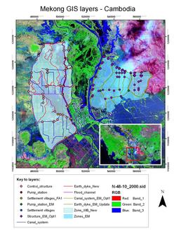
Geographic information systems (which are sometimes known as geospatial information systems) are a set of tools that allow researchers to capture, store, analyse, manage, and present many types of data that are linked to geographical locations. They are extremely powerful systems for analysis of spatial data and are often used to support policy formulation and decision making from local to international scales. A typical visual output from a GIS is shown to the right, where flood model output data for the Meklong River has been overlaid on Landsat satellite imagery so that the flood extent and potential impacts can be analysed.
For queries about this topic, contact Julian Leyland.
View the calendar of events relating to this topic.
Projects
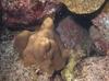
A habitat suitability model for predicting coral reef distributions in the Galápagos Islands
Terence Dawson (Investigator)
As part of a wider project developing a conservation strategy for the marine environment of the Galapagos Islands, this research used multi-variate modelling techniques to develop a habitat suitability prediction model for coral reefs.
A novel method for monitoring air pollution from satellites at very high resolution
Joanna Nield, Jason Noble, Edward Milton (Investigators), Robin Wilson
Developing methods to monitor the clarity of the atmosphere from satellites at 100,000 times the resolution of previous methods. This can then be used to monitor air pollution, correct satellite images and provide data for climate studies. Simulation is used to model the effects of atmospheric pollution on light passing through the atmosphere, and to test the method under 'synthetic atmospheres'.
A spatially-explicit agent-based model of jaguar population dynamics
Jason Noble, Patrick Doncaster (Investigators), Angela Watkins
A single species spatially-explicit agent-based model has been developed that illustrates the role of simulation modelling, integrated with an adapted least-cost modelling approach and real-world geographical data, in exploring jaguar population dynamics.

Automated selection of suitable atmospheric calibration sites for satellite imagery
Robin Wilson, Edward Milton (Investigators)
Ground calibration targets (GCTs) play a vital role in atmospheric correction of satellite sensor data in the optical region, but selecting suitable targets is a subjective and time- consuming task. This project is developing methods to automatically select suitable GCTs, using a combination of remotely sensed multispectral and topographic data.
BRECcIA - Building REsearch Capacity for sustainable water and food security In sub-saharan Africa
The BRECcIA project is aimed at developing research and researchers to understand water and food security challenges in sub-Saharan Africa
Generic Operational Simulation of Civil Unmanned Air Vehicle Operations
Hans Fangohr, James Scanlan (Investigators)
This project creates a generic operational simulation of Unmanned Air Vehicle Operations. UAVs can be valued for their mission-suitability and compared against various configurations.
Multidecadal Sediment Fluxes to Deltas Under future Environmental Change Scenarios
Stephen Darby (Investigator), Frances Dunn
Coastal deltas, on which over half a billion people live worldwide, maintain elevation above sea level by retaining sediment on their surfaces. The aim of this research is to project future fluvial sediment delivery to 47 deltas under environmental change scenarios to assess the sustainability of deltas environments globally.
Network Analysis of Roman Transport Routes in the Imperial Roman Mediterranean
David Potts
This research is designed to explore the nature of the relationships between Portus, Rome, and other selected ports in the Mediterranean and to establish patterns and the changing nature of trading networks derived from the distribution of known Roman artefacts.
Simulating Human Expansion in the Early Pleistocene
Seth Bullock, Fraser Sturt (Investigators), Iza Romanowska
Using Agent-based modelling to investigate the first human dispersal almost 2 million years ago.
Simulation modelling of habitat permeability for mammalian wildlife
Patrick Doncaster, Jason Noble (Investigators), Angela Watkins
Using and integrating least-cost models and agent-based simulations to explore the way in which mammals interact with, and hence move, through fragmented landscapes.
Spatially Embedded Complex Systems Engineering
Seth Bullock (Investigator)
SECSE brought together an interdisciplinary team of scientists working on an ambitious three-and-a-half year project titled. The research cluster spanned neuroscience, artificial intelligence, geography, and complex systems in an attempt to understand the role of spatial organization and spatial processes in complex networks within the domains of neural control, geo-information systems and distributed IT systems such as those implicated in air-traffic control.

The application of automated pattern metrics to surface moisture influences on modelled dune field development
Robin Wilson, Joanna Nield (Investigators)
Areas of sand dunes (known as dunefields) develop complex patterns over time. These are influenced by both the past and present environmental conditions, including surface moisture, vegetation distribution and human impact. This project develops a method of automated pattern analysis which allow the patterns produced by a large number of sand dune evolution simulations (performed using the DECAL model) to be quantified over time.

Traveling and movement during European Late Prehistory
Patricia Murrieta Flores
This project has as main purpose to investigate through spatial analysis and computational modelling the variables and factors that influenced how humans traveled during prehistoric times.
One of the principal objectives will be to clarify the role that certain landscape elements (i.e megalithic monuments) played in terrestrial navigation and territorial definition.
This project is supported by CONACYT (Mexico) as a doctoral research by Patricia Murrieta-Flores under the supervision of Dr. David Wheatley (University of Southampton) and Dr. Leonardo Garcia Sanjuan (University of Seville, Spain). It also counts with the collaboration of Dr. Dimitrij Mlekuz (Gent University, Belgium).
People
 Seth Bullock
Professor, Electronics and Computer Science (FPAS)
 Stephen Darby
Professor, Geography (FSHS)
 Terence Dawson
Professor, Geography (FSHS)
 Hans Fangohr
Professor, Engineering Sciences (FEE)
 Edward Milton
Professor, Geography (FSHS)
 James Scanlan
Professor, Engineering Sciences (FEE)
 Patrick Doncaster
Reader, Biological Sciences (FNES)
Julian LeylandSenior Lecturer, Geography (FSHS)
 Fraser Sturt
Senior Lecturer, Humanities (FH)
Petros BogiatzisResearch Fellow, Ocean & Earth Science (FNES)
 Jason Noble
Research Fellow, Electronics and Computer Science (FPAS)
 Robin Wilson
Research Fellow, Geography (FSHS)
 Alice Ball
Postgraduate Research Student, Electronics and Computer Science (FPAS)
Leonidas BourikasPostgraduate Research Student, Civil Engineering & the Environment (FEE)
 Frances Dunn
Postgraduate Research Student, Geography (FSHS)
Graham ElliottPostgraduate Research Student, Electronics and Computer Science (FPAS)
 Chris Hackney
Postgraduate Research Student, Geography (FSHS)
 Guy Jacobs
Postgraduate Research Student, Electronics and Computer Science (FPAS)
 Patricia Murrieta Flores
Postgraduate Research Student, Humanities (FH)
 Lyuboslav Petrov
Postgraduate Research Student, Electronics and Computer Science (FPAS)
 David Potts
Postgraduate Research Student, Humanities (FH)
 Iza Romanowska
Postgraduate Research Student, Humanities (FH)
 Álvaro Ruiz-Serrano
Postgraduate Research Student, Chemistry (FNES)
 Nick Synes
Postgraduate Research Student, Electronics and Computer Science (FPAS)
 Angela Watkins
Postgraduate Research Student, Biological Sciences (FNES)
 Petrina Butler
Administrative Staff, Research and Innovation Services
Iris KramerNone, None