Earth Observation
This topic consists of research on analysing and processing data from Earth Observation systems, typically satellite and airborne imagery platforms. One particular area of focus is atmospheric correction techniques, which aim to remove the effect of the atmosphere on satellite and airborne imagery. Analysis of the efficacy of these correction techniques can involve significant computer modelling, data assimilation and statistical visualisation.
Much other research within Earth Observation/Remote Sensing involves significant computer modelling, often including the processing of extremely large datasets.
Software which is frequently used in Earth Observation research includes ENVI (a remote sensing data processing package), IDL (a scientific programming language linked with ENVI) and Erdas Imagine (another remote sensing data processing package).
For queries about this topic, contact Robin Wilson.
View the calendar of events relating to this topic.
Projects
A novel method for monitoring air pollution from satellites at very high resolution
Joanna Nield, Jason Noble, Edward Milton (Investigators), Robin Wilson
Developing methods to monitor the clarity of the atmosphere from satellites at 100,000 times the resolution of previous methods. This can then be used to monitor air pollution, correct satellite images and provide data for climate studies. Simulation is used to model the effects of atmospheric pollution on light passing through the atmosphere, and to test the method under 'synthetic atmospheres'.
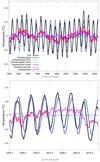
Atlantic ocean meridional heat transport at 26oN: Impact on subtropical ocean heat content variability
Robert Marsh (Investigator), Maike Sonnewald
Local climate is significantly affected by changes in the oceanic heat content on a range of timescales. This variability is driven by heat fluxes from both the atmosphere and the ocean. In the Atlantic the meridional overturning circulation is the main contributor to the oceanic meridional heat transport for latitudes south of about 50? N. The RAPID project has been successfully monitoring the Atlantic meridional overturning at 26? N since 2004. This study demonstrates how this data can be used to estimate the basin-wide ocean heat content in the upper 800 m between 26? N to 36? N. Traditionally the atmosphere is seen to dominate the ocean heat content variability. However, previous studies have looked at smaller areas in the Gulf Stream region, finding that the ocean dominates deseasoned fluctuations of ocean heat content, while studies of the whole North Atlantic region suggest that the atmosphere may be dominant. In our study we use a box-model to investigate fluctuations of the ocean heat content in the subtropical North Atlantic between 26? N and 36? N. The box-model approach is validated using 19 years of high resolution GCM data. We find that in both the GCM and RAPID based data the ocean heat transport dominates the deseasoned heat content variability, while the atmosphere’s impact on the heat content evolution stabilizes after 6 months. We demonstrate that the utility of the RAPID data goes beyond monitoring the overturning circulation at 26? N, and that it can be used to better understand the causes of ocean heat content variability in the North Atlantic. We illustrate this for a recent decrease in ocean heat content which was observed in the North Atlantic in 2009 and 2010. Our results suggest that most of this ocean heat content reduction can be explained by a reduction of the meridional ocean heat transport during this period.

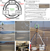
Automated selection of suitable atmospheric calibration sites for satellite imagery
Robin Wilson, Edward Milton (Investigators)
Ground calibration targets (GCTs) play a vital role in atmospheric correction of satellite sensor data in the optical region, but selecting suitable targets is a subjective and time- consuming task. This project is developing methods to automatically select suitable GCTs, using a combination of remotely sensed multispectral and topographic data.
BRECcIA - Building REsearch Capacity for sustainable water and food security In sub-saharan Africa
The BRECcIA project is aimed at developing research and researchers to understand water and food security challenges in sub-Saharan Africa
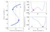
Early warning signals in climate data
Kevin Oliver, James Dyke (Investigators), Maike Sonnewald
Paleoclimatic records reveal that the Earth’s climate system has undergone sharp transitions between
states. Much work has recently been devoted to assessing how likely the current climate is to undergo such a sharp transition. This is motivated by the severe socioeconomic consequences such dramatic changes would entail. Thus, predicting iminent transitions would be very valuable. This review provides an overview of two promising techniques which could potentially be used to assess the stability of components of the climate system. These techniques are degenerate fingerprinting and detrended fluctuation analysis (DFA). It is found that degenerate fingerprinting is more widely used, but that DFA could be more suitable. DFA allows for memory in the time-series, and can give better results with less data. However, the DFA technique is best suited for systems close to the transitions, and relies on calibration with the degenerate fingerprinting technique further from the transition. Applying these techniques to forecast transitions is unfortunately impeded by lack of suitable data. Using data from several sources could overcome this. Thus, the techniques could be very valuable if the use of unevenly spaced data from several sources does
not lead to serious loss off accuracy. However, the techniques are still very useful when assessing underlying dynamics in model output and paleooceanographic time-series.
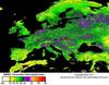
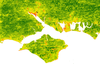
EuroSat4PhenoChanges. Using MERIS for monitoring phenology in Europe.
Peter Atkinson (Investigator), Victor Rodriguez Galiano
Monitoring vegetation phenology at multiple scales in Europe from the GMES satellite sensor time-series: a special consideration to natura2000 areas
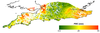
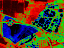
Spatial variability of the atmosphere in southern England
Joanna Nield, Jason Noble, Edward Milton (Investigators), Robin Wilson
No-one really knows how variable key atmospheric parameters such as Aerosol Optical Thickness and Water Vapour content are over relatively small areas. This study aims to find out!

The application of automated pattern metrics to surface moisture influences on modelled dune field development
Robin Wilson, Joanna Nield (Investigators)
Areas of sand dunes (known as dunefields) develop complex patterns over time. These are influenced by both the past and present environmental conditions, including surface moisture, vegetation distribution and human impact. This project develops a method of automated pattern analysis which allow the patterns produced by a large number of sand dune evolution simulations (performed using the DECAL model) to be quantified over time.
The Origin of Aeolian Dunes (TOAD)
Joanna Nield (Investigator)
The overall aim of this project is to understand the genesis and subsequent evolution of aeolian early stage bedforms by quantifying for the very first time the role and importance of flow, transport and surface feedbacks in the initiation and emergence of dunes. This project offers the genuine prospect of surmounting arguably the major enduring research question within aeolian geomorphology, leading to broader insights which will offer knowledge benefits for sedimentary landform studies as a whole.

Validation of GPS-derived water vapour estimates
Joanna Nield, Jason Noble, Edward Milton (Investigators), Robin Wilson
Measurements from GPS base stations can be processed to provide estimates of the water vapour content in the atmosphere. These are lots of these base stations across the world and they take measurements very frequently, making them perfect data sources for scientific use. However, we need to understand their accuracy - and this project aims to do this.
People
 Peter Atkinson
Professor, Geography (FSHS)
 Edward Milton
Professor, Geography (FSHS)
 Robert Marsh
Reader, National Oceanography Centre (FNES)
 James Dyke
Lecturer, Electronics and Computer Science (FPAS)
 Kevin Oliver
Lecturer, National Oceanography Centre (FNES)
 Reno Choi
Senior Research Fellow, Geography (FSHS)
Petros BogiatzisResearch Fellow, Ocean & Earth Science (FNES)
 Jason Noble
Research Fellow, Electronics and Computer Science (FPAS)
Victor Rodriguez GalianoResearch Fellow, Geography (FSHS)
 Robin Wilson
Research Fellow, Geography (FSHS)
 Joseph Abram
Postgraduate Research Student, Electronics and Computer Science (FPAS)
Caroline DuignanPostgraduate Research Student, Biological Sciences (FNES)
 Lyuboslav Petrov
Postgraduate Research Student, Electronics and Computer Science (FPAS)
 Maike Sonnewald
Postgraduate Research Student, National Oceanography Centre (FNES)
Johannes Van Der HorstPostgraduate Research Student, Electronics and Computer Science (FPAS)
 Petrina Butler
Administrative Staff, Research and Innovation Services
Iris KramerNone, None