ArcGIS
ArcGIS is a suite of Geographic Information System software produced by ESRI. It is one of the most commonly used pieces of GIS software, and includes various components which can run on desktops, servers and PDAs.
ArcGIS provides a large number of processing tools for dealing with spatial data, in both raster and vector formats. These processing tools can be extended by the use of models created in the ArcGIS Model Builder, or by writing extensions in a number of programming languages including Python and any .Net language.
For queries about this topic, contact Robin Wilson.
View the calendar of events relating to this topic.
Projects
A novel method for monitoring air pollution from satellites at very high resolution
Joanna Nield, Jason Noble, Edward Milton (Investigators), Robin Wilson
Developing methods to monitor the clarity of the atmosphere from satellites at 100,000 times the resolution of previous methods. This can then be used to monitor air pollution, correct satellite images and provide data for climate studies. Simulation is used to model the effects of atmospheric pollution on light passing through the atmosphere, and to test the method under 'synthetic atmospheres'.
A spatially-explicit agent-based model of jaguar population dynamics
Jason Noble, Patrick Doncaster (Investigators), Angela Watkins
A single species spatially-explicit agent-based model has been developed that illustrates the role of simulation modelling, integrated with an adapted least-cost modelling approach and real-world geographical data, in exploring jaguar population dynamics.
BRECcIA - Building REsearch Capacity for sustainable water and food security In sub-saharan Africa
The BRECcIA project is aimed at developing research and researchers to understand water and food security challenges in sub-Saharan Africa
Generic Operational Simulation of Civil Unmanned Air Vehicle Operations
Hans Fangohr, James Scanlan (Investigators)
This project creates a generic operational simulation of Unmanned Air Vehicle Operations. UAVs can be valued for their mission-suitability and compared against various configurations.
Modelling the morphodynamic evolution of the Ganges-Brahmaputra-Meghna (GBM) Delta over centennial time scales
Stephen Darby (Investigator), Balaji Angamuthu
Around 0.5 Billion people live in deltaic environments where they are threatened by flooding and land loss frequently. Yet, our understanding of the threats posed by land dynamic process remains limited. In this work, we try to address this issue through a land dynamic simulation of the largest and most populated of all the deltas, the GBM Delta, using the CFD software Delft3D for a range of climate change and management scenarios. The results provide new insight into the factors controlling past morphodynamics that, in turn, are helpful when assessing the possible trajectories of future evolution.
Population24/7: space-time specific population surface modelling
Samantha Cockings, David Martin, Samuel Leung (Investigators)
Project funded by Economic and Social Research Council to compute time-specific geographical representations of population distribution.
Simulating Human Expansion in the Early Pleistocene
Seth Bullock, Fraser Sturt (Investigators), Iza Romanowska
Using Agent-based modelling to investigate the first human dispersal almost 2 million years ago.
Simulating Hydro-geomorphic Changes in European Climate Hotspots
John Dearing (Investigator), Ying Wang
This project will simulate the behaviour of hydro-geomorphological processes in a fluvial system over decadal timescales is an important basis for research on catchment environmental management, especially with regards climate changes and human impacts on fluvial system.

Simulating Sleeping Sickness: a two-host agent-based model
Jason Noble, Peter Atkinson (Investigators), Simon Alderton
Sleeping sickness is a vector-borne, parastic disease which affects millions of people across 36 sub-Saharan African countries. Using agent-based models, we aim to gain a greater understanding of the interactions between the tsetse fly vector and both animal and human hosts.
Building an accurate representation will allow the testing of local interventation scenarios including the closing of watering holes, and the selective spraying of cattle with insecticides.
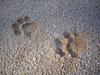
Simulation modelling of habitat permeability for mammalian wildlife
Patrick Doncaster, Jason Noble (Investigators), Angela Watkins
Using and integrating least-cost models and agent-based simulations to explore the way in which mammals interact with, and hence move, through fragmented landscapes.
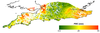
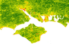
Spatial variability of the atmosphere in southern England
Joanna Nield, Jason Noble, Edward Milton (Investigators), Robin Wilson
No-one really knows how variable key atmospheric parameters such as Aerosol Optical Thickness and Water Vapour content are over relatively small areas. This study aims to find out!

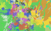
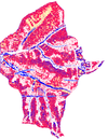
The application of automated pattern metrics to surface moisture influences on modelled dune field development
Robin Wilson, Joanna Nield (Investigators)
Areas of sand dunes (known as dunefields) develop complex patterns over time. These are influenced by both the past and present environmental conditions, including surface moisture, vegetation distribution and human impact. This project develops a method of automated pattern analysis which allow the patterns produced by a large number of sand dune evolution simulations (performed using the DECAL model) to be quantified over time.

Validation of GPS-derived water vapour estimates
Joanna Nield, Jason Noble, Edward Milton (Investigators), Robin Wilson
Measurements from GPS base stations can be processed to provide estimates of the water vapour content in the atmosphere. These are lots of these base stations across the world and they take measurements very frequently, making them perfect data sources for scientific use. However, we need to understand their accuracy - and this project aims to do this.
People
 Peter Atkinson
Professor, Geography (FSHS)
 Seth Bullock
Professor, Electronics and Computer Science (FPAS)
 Stephen Darby
Professor, Geography (FSHS)
 John Dearing
Professor, Geography (FSHS)
 Hans Fangohr
Professor, Engineering Sciences (FEE)
 David Martin
Professor, Geography (FSHS)
 Edward Milton
Professor, Geography (FSHS)
 James Scanlan
Professor, Engineering Sciences (FEE)
 Patrick Doncaster
Reader, Biological Sciences (FNES)
 Fraser Sturt
Senior Lecturer, Humanities (FH)
 Samantha Cockings
Lecturer, Geography (FSHS)
 Reno Choi
Senior Research Fellow, Geography (FSHS)
Petros BogiatzisResearch Fellow, Ocean & Earth Science (FNES)
 Samuel Leung
Research Fellow, Geography (FSHS)
 Jason Noble
Research Fellow, Electronics and Computer Science (FPAS)
 Robin Wilson
Research Fellow, Geography (FSHS)
 Joseph Abram
Postgraduate Research Student, Electronics and Computer Science (FPAS)
 Grant Aitken
Postgraduate Research Student, Geography (FSHS)
 Simon Alderton
Postgraduate Research Student, Geography (FSHS)
Balaji AngamuthuPostgraduate Research Student, Geography (FSHS)
Graham ElliottPostgraduate Research Student, Electronics and Computer Science (FPAS)
 Iza Romanowska
Postgraduate Research Student, Humanities (FH)
 Nick Synes
Postgraduate Research Student, Electronics and Computer Science (FPAS)
Ying WangPostgraduate Research Student, Geography (FSHS)
 Angela Watkins
Postgraduate Research Student, Biological Sciences (FNES)
 Petrina Butler
Administrative Staff, Research and Innovation Services
Iris KramerNone, None