IDL

IDL is a commercial scientific programming language originally created by RSI, and now developed by ITTVIS. It is an array-based language, and provides functionality similar to that of Matlab and Numpy.
It is frequently used for projects in Remote Sensing/Earth Observation and Astrophysics as it is particularly good at image processing, and has a very close integration with ENVI.
For queries about this topic, contact Robin Wilson.
Projects
A novel method for monitoring air pollution from satellites at very high resolution
Joanna Nield, Jason Noble, Edward Milton (Investigators), Robin Wilson
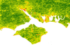
Developing methods to monitor the clarity of the atmosphere from satellites at 100,000 times the resolution of previous methods. This can then be used to monitor air pollution, correct satellite images and provide data for climate studies. Simulation is used to model the effects of atmospheric pollution on light passing through the atmosphere, and to test the method under 'synthetic atmospheres'.
Automated selection of suitable atmospheric calibration sites for satellite imagery
Robin Wilson, Edward Milton (Investigators)
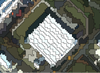
Ground calibration targets (GCTs) play a vital role in atmospheric correction of satellite sensor data in the optical region, but selecting suitable targets is a subjective and time- consuming task. This project is developing methods to automatically select suitable GCTs, using a combination of remotely sensed multispectral and topographic data.
BRECcIA - Building REsearch Capacity for sustainable water and food security In sub-saharan Africa
The BRECcIA project is aimed at developing research and researchers to understand water and food security challenges in sub-Saharan Africa
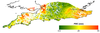
Spatial variability of the atmosphere in southern England
Joanna Nield, Jason Noble, Edward Milton (Investigators), Robin Wilson
No-one really knows how variable key atmospheric parameters such as Aerosol Optical Thickness and Water Vapour content are over relatively small areas. This study aims to find out!

The application of automated pattern metrics to surface moisture influences on modelled dune field development
Robin Wilson, Joanna Nield (Investigators)
Areas of sand dunes (known as dunefields) develop complex patterns over time. These are influenced by both the past and present environmental conditions, including surface moisture, vegetation distribution and human impact. This project develops a method of automated pattern analysis which allow the patterns produced by a large number of sand dune evolution simulations (performed using the DECAL model) to be quantified over time.

Validation of GPS-derived water vapour estimates
Joanna Nield, Jason Noble, Edward Milton (Investigators), Robin Wilson
Measurements from GPS base stations can be processed to provide estimates of the water vapour content in the atmosphere. These are lots of these base stations across the world and they take measurements very frequently, making them perfect data sources for scientific use. However, we need to understand their accuracy - and this project aims to do this.
People
 Edward Milton
Professor, Geography (FSHS)
 Reno Choi
Senior Research Fellow, Geography (FSHS)
 Jason Noble
Research Fellow, Electronics and Computer Science (FPAS)
 Robin Wilson
Research Fellow, Geography (FSHS)
 Justin Lovegrove
Postgraduate Research Student, Mathematics (FSHS)
 Iain Weaver
Postgraduate Research Student, Electronics and Computer Science (FPAS)
 Petrina Butler
Administrative Staff, Research and Innovation Services