Spatial variability of the atmosphere in southern England
- Started
- 1st September 2011
- Research Team
- Robin Wilson
- Investigators
- Joanna Nield, Jason Noble, Edward Milton
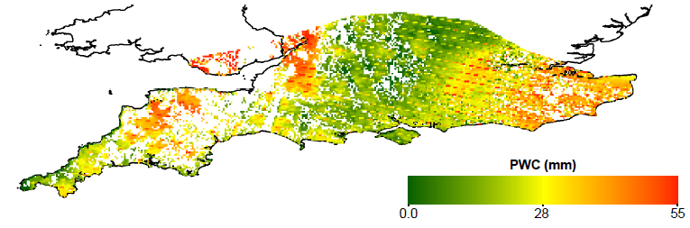
Precipitable Water Content (water vapour amount in the atmosphere) over southern England on the 16th June 2006, as seen by the MODIS sensor on the NASA Terra satellite
Knowledge of atmospheric parameters is important for many applications. I came to this project from the point of view of satellite imaging: it is very important to correct satellite images for the effects of the atmosphere. However, most satellite image corrections are based upon a single parameterisation of the atmospheric conditions across the whole image. However, when the image is large - for example, covering most of southern England, this is unlikely to be true.
This research investigates the variability in key atmospheric parameters across southern England from various data sources, and simulates the effect of this variability on the correction of satellite image data.
A paper based on this research has been submitted to the International Journal of Remote Sensing
Categories
Physical Systems and Engineering simulation: Data Acquisition, Earth Observation
Visualisation and data handling methods: Data Management
Visualisation and data handling software: ArcGIS, ENVI, HDF5, IDL
Software Engineering Tools: Git
Programming languages and libraries: Python, R
Computational platforms: Iridis, Linux, Mac OS X, Windows
Transdisciplinary tags: Complex Systems, HPC, Scientific Computing, Visualisation