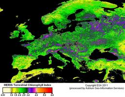
EuroSat4PhenoChanges. Using MERIS for monitoring phenology in Europe.
- Started
- 1st June 2011
- Ended
- 30th June 2015
- Research Team
- Victor Rodriguez Galiano
- Investigators
- Peter Atkinson
Global warming has been evidenced by numerous studies, and can be clearly identified in the recent historical evolution of temperatures across the globe. Increasing temperatures may leads to changes in the phenology of vegetation. The objective of this project is to develop an accurate methodology based on satellite sensor imagery for studying and mapping the phenological response of European terrestrial vegetation to climate drivers. These maps will be available to be used for tuning models of carbon emissions and planning for the management of natural vegetation. The new generation of biophysical time-series from the European Global Monitoring of the Environment and Security programme, at coarse, medium and fine scales, will be used to extract the two main phenological variables (onset of greenness and end of senescence) for the whole European continent at a broader scale, and country and local scales (natura2000 areas). On the one hand, it is expected to evaluate the suitability of different biophysical parameters related to the state of vegetation for the extraction of phenological variables. On the other hand, the influence of the scale factor on the phenology of vegetation is studied, by comparing information obtained at continental, regional and local scales from the different European sensors available. Because of high resolution biophysical parameter are not available for the study of phenology at local scales, a geostatistical methodology will be developed for downscaling the phenological information to the scale of specific sites of ecological importance in order to monitor the state of the natura2000 areas. The specific methodology to obtain phenological variables from biophysical parameters at country scale can be applied to study the changes in phenology in all the European countries. More specifically, the data fusion approach for merging remotely sensed data, which allows operational monitoring the phenology of protected areas, is generalizable.
Categories
Life sciences simulation: Ecology
Physical Systems and Engineering simulation: Earth Observation
Programming languages and libraries: Matlab
