Validation of GPS-derived water vapour estimates
- Research Team
- Robin Wilson
- Investigators
- Joanna Nield, Jason Noble, Edward Milton
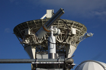
The AERONET sun photometer at the Chilbolton Facility for Atmospheric and Radar Research (CFARR), near Andover, UK
Since early in the development of GPS systems, it has been realised that the GPS signals in the atmosphere will be affected by the amount of water vapour present. This results in a 'slowing down' of the signal, which will manifest itself as an error in the GPS-derived location. This error must be estimated in the process of correcting the GPS location - but rather than just removing this error, we can use the error to estimate the water vapour content in the atmosphere above the sensor. This is the principle of GPS-derived water vapour estimates.
This project aims to validate these estimates against standard methods for measuring atmospheric water vapour: radiosonde measurements and sun photometer measurements from the AERONET network.
Categories
Physical Systems and Engineering simulation: Climate, Earth Observation
Visualisation and data handling methods: Data Management
Visualisation and data handling software: ArcGIS, ENVI, IDL
Software Engineering Tools: Git
Programming languages and libraries: R
Computational platforms: Iridis, Linux, Mac OS X, Windows
Transdisciplinary tags: Complex Systems