Dr. Joanna M. Nield
- Position
- Senior Lecturer
- Institution
- Geography (FSHS)
- Webpage
- http://www.southampton.ac.uk/geography/about/staff/jn1x07.page?
- Contact
- Complete this online contact form to contact Joanna.
Jo is an Aeolian Geomorphology at the University of Southampton. She obtained a BE (Civil and Environmental Engineering) and a BSc (Physical and Inorganic Chemistry) at the University of Adelaide in 2001 and completed a PhD at the same University in 2006, entitled ‘Equilibrium Morphological Modelling in Coastal and River Environments: The Development and Application of Self-Organisation- and Entropy-Based Techniques’. Before joining the University of Southampton in 2007 she undertook an 18 month postdoc in the Department of Geography at King's College London, with Andreas Baas, supported by a Natural Environment Research Council (NERC) grant to develop a Discrete ECogeomorphic Aeolian Landscape model, DECAL.
This page is no longer monitored. Please visit University of Southampton for more details.
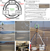
The core of her research as an aeolian geomorphologist centres on furthering scientific knowledge and understanding of key controls on sediment transport and dune mobility in aeolian environments. To do this she develops and applies a number of innovative techniques that focus on the formulation of computer simulation algorithms to model system response to climate and environmental perturbations, in conjunction with the use of terrestrial laser scanning (TLS) to obtain field measurements at a high spatial and temporal resolution.
She is interested modelling long-term evolution and disturbance characteristics of aeolian dune fields and the use of optimisation methods including genetic algorithms and simulated annealing in geomorphic landscape modelling. She is also interested in the use of simple modelling methods such as cellular automaton to pin-point key physical controls in long-term landscape development and the quantification of these through phase space trajectories. Terrestrial laser scanning is a technique with potential which excites her, particularly in its ability to examine spatial and temporal surface changes and link these to processes above the surface, elucidating the importance of feedback between process and form (see her Geography webpage for details of salt pan, vegetation and glacial applications in Botswana, south-west USA and Iceland respectively). Her research is funded by The Royal Society, National Geographic, NERC, EPSRC, NASA, the Royal Geographical Society, the British Society for Geomorphology and WUN.
Jo was recognised for her early career research into aeolian processes and arid landform development by the Royal Geographical Socity, with a Gill Memorial Award, which was presented on the 6th June 2016.
Joanna's team members
 Robin Wilson Robin WilsonResearch Fellow, Geography (FSHS) |
Joint projects with...
 Edward Milton Edward MiltonProfessor, Geography (FSHS) |
 Jason Noble Jason NobleResearch Fellow, Electronics and Computer Science (FPAS) |
 Robin Wilson Robin WilsonResearch Fellow, Geography (FSHS) |
Projects

A novel method for monitoring air pollution from satellites at very high resolution
With Jason Noble, Edward Milton (Investigators), Robin Wilson

Spatial variability of the atmosphere in southern England
With Jason Noble, Edward Milton (Investigators), Robin Wilson

The application of automated pattern metrics to surface moisture influences on modelled dune field development
With Robin Wilson (Investigator)

Validation of GPS-derived water vapour estimates
With Jason Noble, Edward Milton (Investigators), Robin Wilson
Gallery

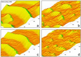
Simulated vegetated aeolian dune landscapes under different environmental conditions. Dune types range from stabilised parabolic dune landscape (d) under ideal growth conditions, through to transgressive transverse dunes (c) and mixed dunes (a) under drought conditions. (Nield and Baas, 2008, Global and Planetary Change)


