Classification
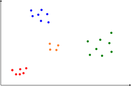
Classification is the method of assigning items to groups (known as classes) based on information about the items. This can be done manually, but is often done automatically by algorithms such as K-Means or Maximum Likelihood, based upon quantitative information about the items.
Classification techniques can be split into two types:
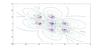
Unsupervised classification can be performed with no a-priori knowledge of the data. For example, a satellite image could be classified into different land-cover classes based entirely on the spectral information inherent in the image, without any human input about what the classes should be.
Supervised classification requires some input about the classes into which the data should be split. For example, the supervised classification equivalent of the example above would be to give the classification routine a list of classes, with examples of the spectra of pixels that fit into those classes. The classification algorithm would then use this training data when classifying the rest of the data.
Classification is a technique that is used in many areas of research. Some fields, such as Remote Sensing/Earth Observation, use classification as a fundamental processing technique, whereas in many other fields data is classified to enable easy visualisation and statistical analysis.
For queries about this topic, contact Robin Wilson.
View the calendar of events relating to this topic.
Projects
A novel method for monitoring air pollution from satellites at very high resolution
Joanna Nield, Jason Noble, Edward Milton (Investigators), Robin Wilson
Developing methods to monitor the clarity of the atmosphere from satellites at 100,000 times the resolution of previous methods. This can then be used to monitor air pollution, correct satellite images and provide data for climate studies. Simulation is used to model the effects of atmospheric pollution on light passing through the atmosphere, and to test the method under 'synthetic atmospheres'.
Application of RNA-Seq for gene fusion identification in blood cancers
William Tapper (Investigator), Marcin Knut
Gene fusions are often the cause of different blood cancers. As such, accurate identification of them provides information on the underlying cause of a cancer, ensuring appropriate choice of treatment. However, due to shortcomings of the currently applied methods for gene fusion identification, some of them escape undetected. We are employing RNA-Seq, a cutting-edge method for sequencing RNA, the messenger of genetic information, to investigate gene fusions.
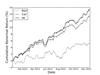
Automated Algorithmic Trading with Intelligent Execution
Frank McGroarty, Enrico Gerding (Investigators), Ash Booth
In this project, we introduce the first fully automated trading system for real-world stock trading that uses time-adaptive execution algorithm to minimise market impact while increasing profitability com- pared to benchmark strategies.

Automated selection of suitable atmospheric calibration sites for satellite imagery
Robin Wilson, Edward Milton (Investigators)
Ground calibration targets (GCTs) play a vital role in atmospheric correction of satellite sensor data in the optical region, but selecting suitable targets is a subjective and time- consuming task. This project is developing methods to automatically select suitable GCTs, using a combination of remotely sensed multispectral and topographic data.
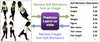
Automatic Image Retrieval with Soft Biometrics for Surveillance
Mark Nixon, John Carter (Investigators), Daniel Martinho-Corbishley
We're investigating ways to automatically describe and identify pedestrians from surveillance footage using human understandable, soft biometric labels. Our goal is to enable surveillance operators to search for pedestrians in a video network using soft biometric descriptions, and to automatically retrieve these descriptions from CCTV images.
Chaotic Analysis of Partial Discharge
Paul Lewin (Investigator), Lyuboslav Petrov
The deterministic character of PD pulses predicted by theory has been shown to be existent for certain PD events. Finding characteristic patterns in phase space enables field-data PD detection with high reliability.
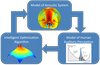
Optimisation of Acoustic Systems for Perceived Sound Quality
Jordan Cheer (Investigator), Daniel Wallace
Acoustic systems have traditionally been optimised on the basis of minimising an objective acoustic measure, such as sound pressure level. The project investigates the use of subjective measures of sound quality, such as "loudness", "harshness" etc. in optimisation algorithms.

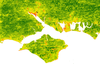
The application of automated pattern metrics to surface moisture influences on modelled dune field development
Robin Wilson, Joanna Nield (Investigators)
Areas of sand dunes (known as dunefields) develop complex patterns over time. These are influenced by both the past and present environmental conditions, including surface moisture, vegetation distribution and human impact. This project develops a method of automated pattern analysis which allow the patterns produced by a large number of sand dune evolution simulations (performed using the DECAL model) to be quantified over time.
People
 Paul Lewin
Professor, Electronics and Computer Science (FPAS)
 Frank McGroarty
Professor, Management (FBL)
Edward MiltonProfessor, Geography (FSHS)
Mark NixonProfessor, Electronics and Computer Science (FPAS)
 Paul Skipp
Reader, Biological Sciences (FNES)
John CarterSenior Lecturer, Electronics and Computer Science (FPAS)
Jordan CheerLecturer, Institute of Sound & Vibration Research (FEE)
Srinandan DasmahapatraLecturer, Electronics and Computer Science (FPAS)
Petros BogiatzisResearch Fellow, Ocean & Earth Science (FNES)
Btissam Er-RahmadiResearch Fellow, Management (FBL)
 Jason Noble
Research Fellow, Electronics and Computer Science (FPAS)
 Robin Wilson
Research Fellow, Geography (FSHS)
- -Postgraduate Research Student, Electronics and Computer Science (FPAS)
 Harry Beviss
Postgraduate Research Student, Electronics and Computer Science (FPAS)
 Ash Booth
Postgraduate Research Student, Electronics and Computer Science (FPAS)
Leonidas BourikasPostgraduate Research Student, Civil Engineering & the Environment (FEE)
Michael ChesnayePostgraduate Research Student, Institute of Sound & Vibration Research (FEE)
 Joshua Jeeson Daniel
Postgraduate Research Student, Engineering Sciences (FEE)
Marcin KnutPostgraduate Research Student, Medicine (FM)
Konstantinos KouvarisPostgraduate Research Student, Electronics and Computer Science (FPAS)
Gregory ParkesPostgraduate Research Student, Electronics and Computer Science (FPAS)
 Lyuboslav Petrov
Postgraduate Research Student, Electronics and Computer Science (FPAS)
 Daniel Wallace
Postgraduate Research Student, Engineering Sciences (FEE)
Jess JonesTechnical Staff, iSolutions
 Petrina Butler
Administrative Staff, Research and Innovation Services
 Marijan Beg
External Member, Imperial College London
Brian BonneyNone, None
Enrico GerdingNone, None
Iris KramerNone, None
Daniel Martinho-CorbishleyNone, None
Daisuke SasakiNone, None
Doroteya StaykovaNone, None
William TapperNone, None